Discovery in the Modern Landscape
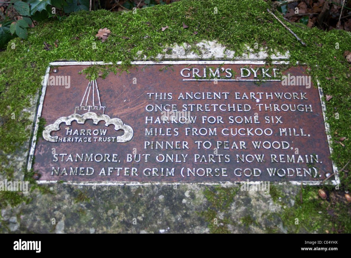
Tucked between suburban developments and woodlands in northwest London lies an enigmatic ridge known as Grim’s Dyke. At first glance, it might seem like a natural mound – overgrown with trees and even littered in spots – but a closer look reveals it as an ancient earthwork. This linear bank-and-ditch runs across parts of Harrow Weald, Pinner, and Stanmore, though modern construction has obscured much of it. Originally, Grim’s Dyke stretched roughly six miles west-to-east – from Cuckoo Hill in Pinner to Pear Wood in Stanmore – cutting across the high ridge of the Middlesex/Hertfordshire border. Today only fragments remain in parks, golf courses, and even private back gardens, but these remnants still stand up to 2 meters high, hinting at a feature that was once far more imposing.
Local antiquarians and archaeologists “rediscovered” Grim’s Dyke in the 19th and 20th centuries, mapping its course through the countryside. As early as 1535, documents note the name Grimesdich (Grim’s Ditch) in this area. Walking along it now, one literally traverses a piece of pre-Saxon Britain hiding in plain sight between Tesco supermarkets and 1960s housing blocks. The dyke’s strategic placement on a high ridge once afforded commanding views – it overlooks routes like Watling Street, the old Roman road, and the plains toward Londinium (London) and Verulamium (St Albans). Its location and size made it a subject of speculation from the start: Who built this earthwork, and why? Locals have spun tales of ancient warriors and even gods shaping Grim’s Dyke, setting the stage for a deeper investigation.
Myths and Legends: Boudica’s Last Stand and Woden’s Work
Grim’s Dyke’s mysterious origin has invited a rich tapestry of folklore. The very name “Grim” offers a clue to its legendary status. In Old English, Grim was a by-name for Woden (the Anglo-Saxon incarnation of the Norse god Odin). To later inhabitants who stumbled upon this massive earthen bank with no known builder, attributing it to a god must have seemed logical. Some traditions interpret Grim more darkly as a reference to the devil or a goblin, creatures capable of superhuman feats of construction. One Saxon legend even claimed the devil dug the ditch in a single night – a testament to the awe these structures inspired.
Another powerful legend tied to Grim’s Dyke is the story of Queen Boudica (Boadicea) of the Iceni tribe. Boudica led a famous uprising against Roman rule in AD 60–61, during which her forces burned Roman Londinium (London) and Verulamium (St Albans). Local lore in the Harrow district holds that Boudica’s campaign swept through this very ridge. In fact, a hillock on Stanmore Common has long been dubbed “Boadicea’s Grave” – the supposed burial mound of the warrior queen. According to one Victorian account, after sacking London, *“she fought her way on to Verulamium and took over a region between St Albans and Hampstead”—placing her right in the Grim’s Dyke vicinity. People have speculated that Boudica made her last stand along this ridge, using Grim’s Dyke as a defensive earthwork to hold back the pursuing Romans.
Such legends are fueled by evocative details on the landscape. Beside an old pond on Stanmore Hill – dubbed “Caesar’s Pond” – a plaque notes that a Roman detachment was once stationed here, and local tradition claims Boudica’s rebel army camped by these waters to refresh themselves. Even in the late 19th century, residents relished the connection: W.S. Gilbert (of Gilbert & Sullivan fame), who lived at Grim’s Dyke House, would point out to guests the spot “about a mile from here” where *“Boadicea killed herself to escape the Roman general”—according to legend. The image of the proud queen poisoning herself on the very ridge behind his gardens must have been a dramatic selling point for the estate’s tour.
While thrilling, we must ask: Is there any truth to it?
Investigation: What the Earthwork Really Is (and Isn’t)
To evaluate the Boudica claims, we first need to understand what Grim’s Dyke actually is. In ancient Britain, a “dyke” typically means a linear earthwork consisting of a ditch alongside a raised bank. These features were dug by hand with primitive tools, the soil from the ditch piled up to form the embankment. Unlike a hillfort or enclosure, a linear dyke does not loop around to encircle an area; instead it stretches across the landscape like a long scar. Dykes varied in scale and purpose – some were massive defensive ramparts, others simple boundary markers.
Several small excavations and surveys have taken place at Grim’s Dyke. These investigations unearthed tantalizing clues about the dyke’s date and function. For example, a hearth (fire pit) excavated in the bank yielded charcoal that was radiocarbon dated to around AD 50 (give or take ~80 years). This places the construction or use of the dyke in the later Iron Age to early Roman period, roughly the right era for either the Catuvellauni (the local tribe) or the early stages of Roman conquest. Additionally, archaeologists recovered Iron Age flint flakes and Belgic pottery in the vicinity, suggesting everyday activity near the dyke in pre-Roman times.
All this evidence firmly establishes Grim’s Dyke as a prehistoric earthwork, likely built in the Iron Age, before or around the time the Romans arrived in Britain. But was it a military fortification? The dimensions do not support that interpretation. Where it survives best, the bank is around two meters high with a shallow ditch 6–8 m wide. In some sections the ditch exists on both sides of the bank – unusual for defensive ramparts, which usually defend from one direction.
More telling, there is no evidence of palisades, weapon caches, or mass graves. Grim’s Dyke is therefore unlikely to have served as a military bastion. Scholars instead interpret it as a territorial boundary, possibly erected by the Catuvellauni to mark lands or limit livestock. It may have been useful for slowing movement or asserting power but was not designed to withstand prolonged attack. The lack of direct evidence connecting the dyke to a specific battle or conflict reinforces this theory.
As for Boudica? There is no credible evidence that she made her last stand here. Modern historians generally agree that the decisive battle of the Boudican Revolt occurred somewhere along Watling Street – likely in the West Midlands or Northamptonshire, well away from the Harrow ridge. While Boudica certainly moved between St Albans and London, there is nothing to link her army directly to Grim’s Dyke. It is far more likely that this earthwork predates or postdates her rebellion. At best, her troops may have passed near it on their march.
Grim’s Dyke may also have had multiple phases of use. Some theories place sections of the dyke as post-Roman, possibly reused by Saxons or others as territorial boundaries. Large stretches were later incorporated into medieval parish boundaries, which hints at their lasting influence long after the dyke’s original builders were forgotten.
Conclusion: Separating Fact from Fiction
Grim’s Dyke in Harrow is a fascinating case of overlapping history and mythology. On one hand, the archaeological record reveals it as an Iron Age boundary marker, possibly built by the Catuvellauni. On the other, rich folklore has overlaid it with images of Woden, devils, and warrior queens. While Boudica almost certainly did not build or die at Grim’s Dyke, the legend persists because it adds emotional weight to a visible yet unexplained feature of the land.
Whether seen as the ghostly rampart of a mythical queen or a pragmatic earthwork built by long-lost tribes, Grim’s Dyke continues to inspire curiosity. It reminds us that every ditch, mound, or old track might carry not just soil and stone, but stories – the ones we can prove and the ones we love to tell.
References: - London & Middlesex Archaeological Society field reports - Harrow Heritage Trust and Harrow Council historical signage - Historic England database on Scheduled Ancient Monuments - Local folklore archives and oral history collections - Academic journals on Iron Age Britain and Romano-British earthworks - Interpretative signage at Stanmore Hill and Caesar’s Pond - British Museum records on Belgic pottery and Catuvellauni settlement patterns - Publications by W.S. Gilbert on Grim’s Dyke estate - Archaeological excavation notes (1979, 1950s) near Grim’s Dyke Hotel